CYHA News
The Monthly Newsletter of Chelmsford YHA Local Group
July 2020
The Oldest Road in Britain
Following the cancellation of our holidays and travel plans, we were looking for something relatively local to keep us occupied. Inspired by Mike & Cress’ walks on St.Peter’s Way, we chose to walk the Icknield Way Path as a series of day trips. The half-way point of this 112-mile route is less than 5 miles from our house.
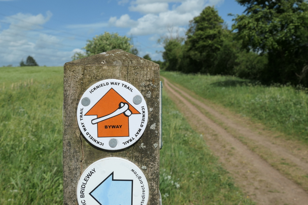
The Icknield Way is an ancient trackway crossing southern and eastern England. Along with Ermine Street, Fosse Way and Watling Street, it is one of the four highways of medieval England. The original route was made up of a number of roads, some running parallel, and older texts have it running from Wiltshire to Norfolk or from Salisbury to Bury St Edmunds, but then there were also parts of it as far north as Rotherham and York. What is clear is that it was a route for trading that the Romans embraced as part of their road network. If you look on a map you’ll see the route follows the modern A505 and A11. The name is a bit of a mystery, but early spellings (Icenhilde weg, Icenilde weg) indicate it was probably named after the local celtic tribe, the Iceni.
The modern route of the footpath starts at the end of the Ridgeway (another long distance path) at Ivinghoe Beacon and travels northeast across Buckinghamshire, Bedfordshire, Hertfordshire, Cambridgeshire, Essex and Suffolk. It stops about half a mile short of the Norfolk border at Knettishall Heath near Thetford, where, if you were minded, you could pick up the Peddars Way and keep going to the North Norfolk coast.
Although some of the prehistoric route is now under major roads, much of the footpath follows the ancient byways and quite a lot of it is made up of wide trackways that you could certainly imagine people herding their animals along. Modern town development has crowded the way in places, but the bit round Luton was surprisingly nice and coming down into Royston was positively delightful.
If you plotted the Icknield Way on a geological map, you would see that it follows the gentle sweep of chalk that flows from the Chilterns into East Anglia. For much of the walk you are up on these chalk downs. Our starting point, high on Ivinghoe Beacon, is an area known for its butterflies, including the Adonis Blue with its complicated relationship with the local ants. We definitely saw a Chalk Hill Blue (much more common) and several speckled-brown ones that in our ignorance could have been something dead common or the incredibly rare Duke of Burgundy.
As we passed from Buckinghamshire into Bedfordshire we walked round the perimeter of Whipsnade Zoo. It’s not every walk in this country that gives you views of antelope, rhino and wallabies. We also saw numerous red kites gliding above the chalk escarpment. From here it’s not far until you are at the Tree Cathedral. Planted in the years after the Great War as an open air commemoration to those who died, it was the perfect place for a quiet lunch before heading back up the hill to the Dunstable Downs.
Unsurprisingly, given the beautiful weather, there were a lot of people about but plenty of space for everyone. I even managed to find a bench to sit on whilst I waited for Dave to bag the Bedfordshire county top – a trig point located rather uninspiringly in a car park.
Moving from Bedfordshire into Hertfordshire, you pass through some gorgeous villages with some fine-looking hostelries – if only we weren’t under lockdown. We were also passing hillforts, castles and barrows. A real slice through our history as well as six counties.
Several Anglo-Saxon ditches run at right angles to the Icknield Way. Some, like Devils Dyke and Fleam Dyke, you may have heard of, but a few miles out from Royston we found Heydon Ditch. Probably boundary markers, perhaps to control trade, but today they are a haven for wildflowers. Lots of different kinds of vetch, knapweed, plantain, poppies, a cornflower and the entirely alien-looking broomrape.
Coming through Hertfordshire, Cambridgeshire and into Essex, you are still fairly high on the chalk, with huge views. As you approach Newmarket and Suffolk, the landscape gets more rolling and the track is a bit like a rollercoaster. Gradually the hills level out and the river valleys open into heathland and the distinctive sandy soils and Scots pines of the Brecks. We lost count of all the interesting churches, villages and pubs we’d like to go back to when everything re-opens. A route well worth the walk!
Ali
Please send any comments on these pages to Dave Plummer